Fondfield Links
- a typical East Gate night and day | a typical day in Fondfield
- Green Goose Inn and Stables | folks | prices | room listings
- Fliton's Jewels, Rings, appraisals and gem-cutting, Fondfield
- S1: Sage Grt Xyl ( flora and fungi) | S 2: Money Changers | S 3: Money lenders
- S 6: Tailors, 5 | S 8: Jonran's General Store | S 10: Cobblers, 2
- S 15: Potter | Zrani's Blacksmith Shop | S16: Jara's General Store
- Hx: Single family homes map | Qx: family homes, near The Questors
- Dx: 2 story Duplex family homes
This is an adventure that took place under Fondfield.
Many of the player characters were off adventuring, when some servants disappeared, and one was found dead, in a store room under Falla Keep. This keep is the home of one of the town commanders. A ‘scratch force’ of adventurers went down to find out what happened.
What they found was, expect a tougher force than they figured it would be.
location of Falla Keep in Fondfield.
Bill George
Categories
South Hemisphere
Cedarlair, Dank Forest
Posted
Dank Forest Links
- Dank Forest entrance page
- Bigdale
- Cedarlair
- Meldale
- Sara's General Store, Meldale
- Castle in Meldale
- Noble Houses and Knightly Orders in Dank Forest
- history
- Tok the Adventurer: Brillar, Dank Forest, NPC
- Doran Zel-Ha, wood elf, fighter/magic-user, Brillar, Dank Forest, NPC
- leaders
- Geography and resources
- population
1) Joel’s General Store and Stables
2) public fountain and park
3) boarding house with some rooms for travelers
4) barracks for militia and military
5) public ponds and wells
6) watering troughs for horses or mules
7) keep
8 ) shops
9)Merchant houses
( not all are in use)
10) Sage
11) tax collector
Gate at B1: West gate
Gate at F10: East Gate
Gray buildings are barracks for militia or military. Light green buildings are for merchants. Purple buildings, except the circular one, are for town leaders or wealthy merchants. There are ponds and horse troughs around the town. The very small squares are small guard towers. That is a cobblestone footpath connecting the square towers, not a wall.
The town walls are near the map border, and have round towers on them.
Updated map on Feb 22, 2021.
Bill George
Categories
Dank Forest, Cedarlair
Bigdale, Dank Forest
Posted
Dank Forest Links
- Dank Forest entrance page
- Bigdale
- Cedarlair
- Meldale
- Sara's General Store, Meldale
- Castle in Meldale
- Noble Houses and Knightly Orders in Dank Forest
- history
- Tok the Adventurer: Brillar, Dank Forest, NPC
- Doran Zel-Ha, wood elf, fighter/magic-user, Brillar, Dank Forest, NPC
- leaders
- Geography and resources
- population
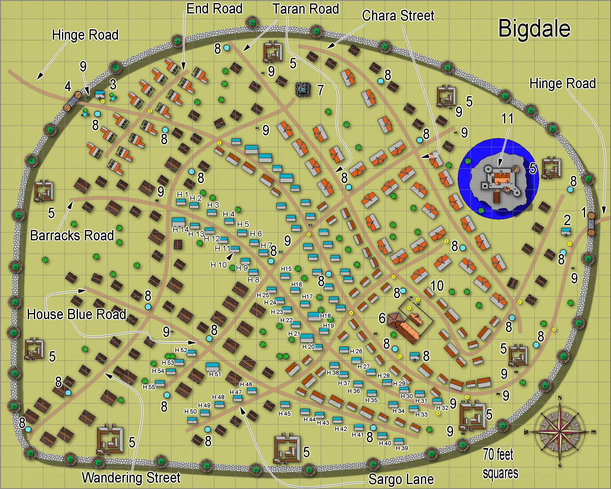
Map upped from 1200 pixels to 2000 pixels on January 28, 2019.
1) West gate
2) Guard shack and tax collector
3) tax collector
4) East gate
5) Barracks for militia or military, 2 are not in use
6) boarding house with half of the rooms to rent for travelers.
7) public water fountain, decorative
8) public drinking water fountain
9) trough for horses and mules
10) Joe’s General Store
11) Castle
almost at full capacity for military.
( but not well kept, 2 trees growing in the moat)
guards on the walls, not all towers have anyone in them.
Most towers are used for storage.
Map updated: Feb 22, 2021

Author
Bill George
Categories
Dank Forest, Bigdale
Meldale, Dank Forest
Posted
Dank Forest Links
- Dank Forest entrance page
- Bigdale
- Cedarlair
- Meldale
- Sara's General Store, Meldale
- Castle in Meldale
- Noble Houses and Knightly Orders in Dank Forest
- history
- Tok the Adventurer: Brillar, Dank Forest, NPC
- Doran Zel-Ha, wood elf, fighter/magic-user, Brillar, Dank Forest, NPC
- leaders
- Geography and resources
- population
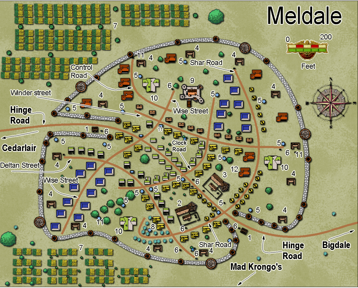
1) guard shack
2) boarding house
3) boarding house with some rooms for travellers
4) barracks for militia and military ( only 5 are in use)
5) public ponds and wells
6) watering troughs for horses or mules
7) farm land
8 ) private water supply, has 3 guards at all times
9) castle, has a token force operating it
( less than half of what should be there)
10) manor houses, minor nobility
11) pond, over grown
12) Sara’s General Store
Some odd street names ? Yes. Why are they named Control Road, Winder Street, and Clock Road ? Because in Ancient Times, they were part of a clock. The remains are buried around 20 feet down. Clock Road covers notches cut in rock, the path for a gear… The people who lived here long ago maintained the clock.
Sometimes a person traveling through the area will dream of a giant clock ‘tick tock tick tock’. Any mention of that to a local will get a shrug and then the traveler is ignored.
Do locals dream of Giant Clocks ? Yes, but they put it to too much food before sleeping for the night.
Does the long gone Giant Clock dream ? It isn’t here to be asked questions, it has vanished from Crestar.
Smaller than Bigdale, population is 450.
The walls don’t make a complete circuit, and there are lots of thatched roof houses along the main road through town. Two large Inns, across the road from each other. Meldale does have public ponds.
There isn’t much here.
Updated map: Feb 22, 2021

Author
Bill George
Categories
Dank Forest, Meldale
Grand Duchy of Winifree
Posted
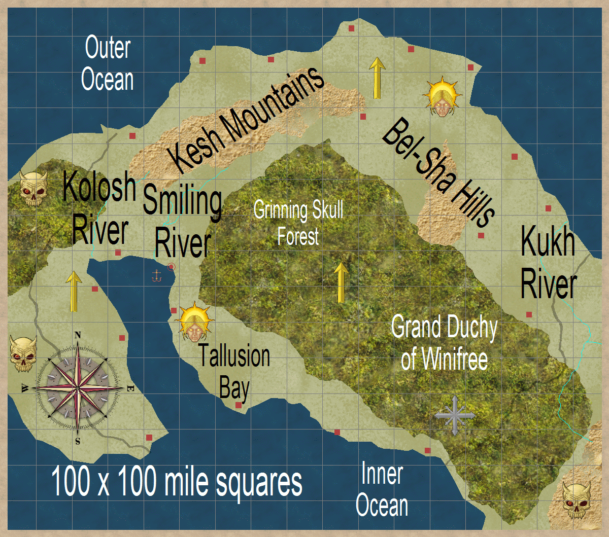
Near Groz, on the Inland Sea. North of Winifree is the Outer Ocean and the equator.
The Kukh River to the lower right has two branches coming down from Troll Mountains. They join up and head for the Outer Ocean.
The old name for the Mound Forest was Grinning Skull Forest. Somewhere in there, so it is said, is a large happy grinning skull.
The Kukh River doesn’t always flow and provide healthy drinking water. Sometimes is is very dangerous to drink from it.
The Smiling River and Kolosh River run clean and often. The rains that fall on Toola Mountains keep them flowing.
The Grand Duchy of Winifree is mostly Lawful and Good, but not Lawful Good. They are surrounded on land by Evil. The Troll Mountains are best to be avoided.
The small red squares on the map are generalized locations of castles.
Note that one end of Mound Forest is Lawful, the other is Chaotic.

Author
Bill George
Categories
South Hemisphere, Grand Duchy of Winifree