Posted


Tantalow didn’t like sharing the island. He wanted it to be all under his control.

One day he developed a method for opening a magic Gate.

He should have worked on learning more about it and the possible worlds and planes he could contact.

He wanted to fool the newcomers, so he disguised himself as a 6’ tall bunny rabbit. To help them be unafraid.

Bad Idea.

The beings who came through loved to hunt.

Their strange weapons made loud noises, and fired high speed pellets.

Some of Tantalow’s subjects who were watching from a distance, slowly backed into the nearby forest. Others sounded the danger horns. Those horns were one of the few things common to all 3 groups. And used during major emergencies affecting all of them.

Didn’t do them much good.

The attackers went after anyone armed. Spell casters took out many of them. Then the Gate was closed. But not before a metal object came out, it had a moving turning gun. Larger than the ones carried by the invaders. It blasted a few places, then broke down. It was set afire with oil lamps thrown at it.

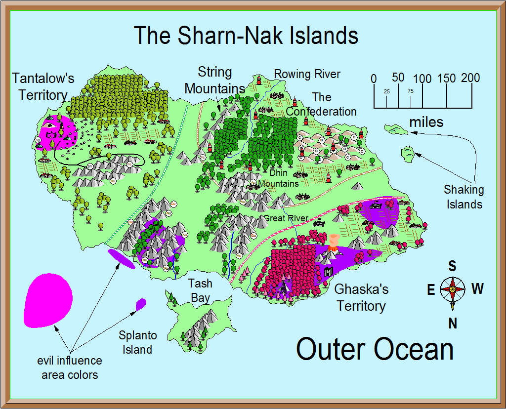
One group of the invaders threw round metal objects into the water near Tash Bay, to go fishing with. Minor earthquakes resulted.

Something, or several somethings, deep in the water cast mucus nets up onto shore and dragged some of the invaders into the sea. Larger explosives were tossed into the sea.

Archers of The Confederation took this opportunity to fire arrows into the invaders. Some died, but so did many of the archers.

Some Islanders fled by boat, some were spotted by the invaders. Some got out of range of the weapons, some didn’t.

The ones who fled to the Shaking Islands drowned when the islands sank into the depths.

Earthquakes rocked the island, knocking some mountains down. Another island rose to the surface over many months.

Suddenly bolts of lightning rained down from a clear blue sky. What was left of the stones making up the Gate vaporized. The nearby monolith ring was untouched.

The mountains on Splanto Island vanished. Some say they rose into the sky.

Over many years the original inhabitants once again rose from the ashes. Some went out to the new island and settled there. Some of the original evil inhabitants survived. Most of the good survived. None of the invaders.

Many a brave islander died setting traps or attacking the invaders with makeshift weapons. Some used their bare hands. Evil and Good cooperated against the common enemy. They were no longer so quick to attack one another, even after the common goal of taking out the other planet invaders was complete. Stories were told of their sacrifice for many long years.

As a reminder to not meddle in magic that can create Gates, they called the islands Tantalow’s Island Group.

Tantalow would be remembered, but not exactly like he wanted.


Notes on Shaking Islands:

Foundations out of sandstone and limestone. Ocean currents and wave action over the centuries had weakened their underpinnings.

The earthquakes shattered the sandstone, leading to the islands’ collapse into the sea.

Tantalow Island is a sea mount. The Shaking Islands were leftovers from the sea mount forming and were poised on one side of the sea mount. Not substantially connected to Tantalow, they barely hung there… just waiting for a strong earthquake or explosion to cause them to fall apart and sink into the sea. The invaders caused earthquakes that lost them forever. Down in the depths are bones, the goods, coins, armor, and weapons that haven’t rotted or rusted, of those islanders who fled the invaders.

The other islands are sea mounts not connected to Tantalow.

large png, Sharn Nak Islands


Author
Categories

Posted


Total population is about 120,000 in the villages, towns, and cities. This doesn’t
include monsters. Single tree symbols represent a small area of trees, from
1-10 acres.

Tantalow’s Island is about 260,000 square miles
Cities: Wasto (15,000 seaport) ; Shessor ( 18,000 seaport) ;
Chelo (19,000 capital)

Towns: Lower ( kinda near Lower Dhin Mts. ) (4,000) ;
Upper (near Dhin Mts.) (4,500) ; Sta (3,600)

Villages: Field (2,000) ; Seltah ; Oro (2,450) ;
Seko (2,000) ; Yell (2,600)

Small villages: Kha (1,200) ; Sedo (1,100) ; Blue (900)

Star Island is about 14,700 square miles
City: Yeg (9,000) ; Town: Sea Star (3,000)

Villages: Gert (2,300) ; Rak (450) ; Setto (750) ; Keep: Sarn and 3 watch towers

Sea Star is the seaport ; Yeg has only an easily defended port area for resupply.

Beggar Woods is about 30 miles across.

Spill Island is about 9,800 square miles
City: Way Ton (7,000) ; Town: Way Ut (3,000)

Village: Spill (1,950) ; several small planting/harvest villages

Way Ut is the sea port. Way Ton has no ships.


The smaller villages on these islands have from 150-325 people. Some of the hommlets, with a population of 50 and under, are there mainly as planting and harvest villages. There are caretakers, with the population increasing as folks arrive to plant crops or harvest food grown here. There are also many hommlets of less than 100 people that are not mapped.


Roads:
Dar goes from Tarag Castle, Dar Castle, then Wasto past Field and Danno Castle and
ends at a watch tower

Tago goes from the west end of Tantalow’s Island past Yell,
Monto Crater, over the Great River, past Oro, over Loner River
and over to Sedo, Lower, and Kha, past Chelo and Karno Keep,
and ends at Tago City.

Lower Tago is less traveled. It goes from Tago Road over the
lower Loner River, to Blue, then lower Great River and stops
near the coast towards a lonely watch tower. For some reason,
many folks act like its unlucky to travel on Lower Tago Road.

Star and Spill Islands roads are unnamed.

Passages to Grand Harbor: While all 3 easily accommodate ships, Dar is over 3,000 feet deep. Strange rip currents can cause problems in Dar Passage for all but the sturdiest of ships.


one acre is: 4,840 sq yards; 43,560 sq ft.; 1/640 sq mi. For purposes of acres on these islands, they are 200’ × 217.8’. One acre equals 0.4047 hectares.


a few Distances:
Seko Village to Taro Road: about 50 miles

Lower Tago Road bridge to Blue village: 20 miles

From Lower to Upper: 50 miles

Lower Dhin Mountains to Dhin Mountains: about 25 miles

From Sta to the tower at the end of Dar Road: about 100 miles ( no road)

Sarn Keep around to Sea Star: 130 miles

watch tower to Sarn Keep: 30 miles

Seko to Yell: 33 miles across the fields ; by road 87 miles

Upper to Tarn Keep: 80 miles

Monto Crater to Yell: 45 miles ; Sedge Keep is downwind of Monto

Blue to Oro: 40 miles

Seltah to Tago Road: 25 miles

Gap between parts of Seko Forest: 50 miles


River sizes
Great River is 225 miles long

Rowing River is 230 miles long.

Tah River is about 60 miles long

X River is about 30 miles long


Author
Categories

Posted


Part of the Torlo Sea Mount is shallow enough to provide a home for various fish. Making it a prime location for a fishing ground.

The two deeps have not been explored.

A rumor on the islands is that there was an early conflict between the fishermen and some one or some thing living in the deeps.

The fishermen and a magic-user were able to make a treaty with whomever or whatever lives down there due to them not eating the same fish.

Some months the sea mount is off limits to the fishing fleet.

There have been some minor conflicts over the centuries, but the majority of the time peace is here.

Woe to the Slaver or Pirate ship that attacks these fishermen.


Author
Categories

Posted


farm land: corn, apricots, apples, cattle, vegetables, other typical farm animals

forests: several forests

water: streams, several rivers, bays, fishing is good

mountains: 3 mountain ranges. Several lone peaks

typical terrain: mostly flat, good farm land. Cities, towns, and castles are well kept. Part is desolate, ruins. And old evil ruins on Spill Island.


Author
Categories

Posted


Grand Harbor has no anchorages, so many are confused as to how it got its name.

Way-ton is currently the only named location on this island. This island is a bit chaotic.


Author
Categories

Copyright by me, Jim. 1980-2050

Unless held by others.