Darshan Links
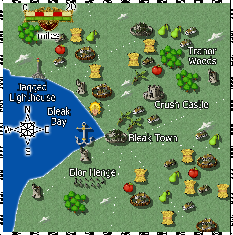
Shows a few of the local sites, crops, and a henge. 100 mile map.
"Welcome to Crest of a Star; these maps and other graphics are only for playing D&D type games. They are copyright and not to be used for other purposes. If you have them on your site, please remove them. Thank you."
Hi and welcome to my Crest of a Star site ! This site is my first edition AD&D materials.
I have added to the maps, people, etc. since I bought Campaign Cartographer 2 around 23 or so years ago. I now have CC3+ and all of its add-ons.
Link in the Home text at the top of this drop down will bring you back to the front page of this site.
My other rpg sites below.
Posted
Shows a few of the local sites, crops, and a henge. 100 mile map.
Author
Bill George
Categories
Fondland, Bleak Town
Posted
Upped the map from 1200 pixels to 2000 pixels on January 28, 2019.
A country to the west of the Mountains of Death ( The Great Open is between
Trillolara and these mountains.). An unknown, to Trillolarans, nation. (Alignment: NG)
This area started out as a collection of towns.
No set plan for any one of them to dominate the area, just turned out Bluening was the one in charge after years of development in the area.
They don’t exact tribute, but you must pay your taxes. Five percent of all income.
Author
Bill George
Categories
South Hemisphere
Posted
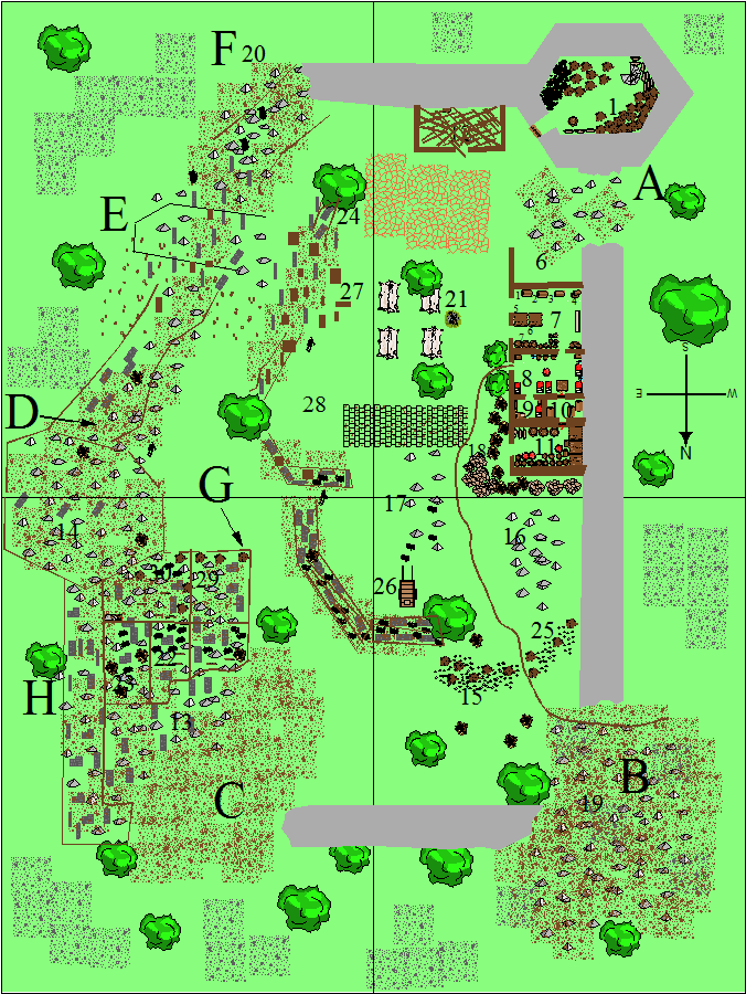
Shagtor, odd-shaped, castle:
Several debris fields, former walls, living quarters, and storage areas.
Each debris field has a chance of causing slips and falls.
Some of the smaller debris areas look deliberate built, like they were placed there as a defense by the former inhabitants.
roll percentile dice: if the dice show a number at or below the percentage, the character must roll the number of six-sided dice vs. dexterity.
If the roll is over the character’s dexterity, a fall occurred. The amount of damage is an estimate made by the DM based on the amount over the character’s dexterity. Typically 1d6 hp. If on a large mound of rocks and other debris ( such as C and F), 2-3d6 hp. 5% – 20% chance to have a limb trapped by a rock.
chance vs Dexterity
A 10% 4d6
B 25% 4d6
C 90% 5d6 lots of loose rocks
D 20% 4d6
E loose blocks scattered, easy to walk through, horses must be led. Area is marked by lines.
F 95% 5d6 lots of loose rocks
Rubble in area B, area 19, is 30 feet high in the center.
Wall in area D is 3 feet high, old tower is 15 feet high slants up to 60 feet high near the lord’s quarters/room 26.
Area F is 15 feet high.
The interior wall, near/between the two towers is 5-7 feet high of debris, loose rocks.
The outer intact walls are 20 feet thick, 30 feet high.
The walls of rooms 6-11 are 10 feet high.
Rubble areas 17 and 18 are 5 feet high in the center.
Area B is 30 feet high in the center.
Rubble areas 15 and 18 are purpose built by the present inhabitants as a defense to cover the entrance path.
Rubble area 16 is 5 feet high much of its length. 6 foot gap between it and the wall.
Between E and 27 its possible to walk carefully and avoid all stones. makes the characters easy targets for missle weapons though.
Wall areas 23 and 24 are intact.
The only inhabitable areas are: 1, 6, 7, 8, 9, 10, 11. And the 4 tents near the well at 21.
Author
Bill George
Categories
South Hemisphere
Posted
I’m not certain now where I had placed this in my campaign, so I’ll just place it in Trillolara’s section.
There are many difficult and injury causing paths to take into the interior of this old castle. I made the hidden parts visible so other DMs could run this adventure.
The only safe ones are the B and E paths. They should be easily spottable by any thief or ranger looking for a path. I made all of the hidden areas visible so other DMs could run this adventure.
Checking is done by rolling the listed number of d6 dice. If the roll is over their dex, they fall.
A: 10 percent chance to fall per step. 4d6 vs. Dex
B: off path: 25 percent chance to fall per step. 4d6 vs. Dex
C: 90 percent chance to fall per step. 5d6 vs. Dex
D: 20 percent chance to fall per step. 4d6 vs. Dex
F: 95 percent chance to fall per step. 5d6 vs. Dex
G: walls still remaining. 20 feet tall. no path
H: 25 percent chance to fall per step. 4d6 vs. Dex
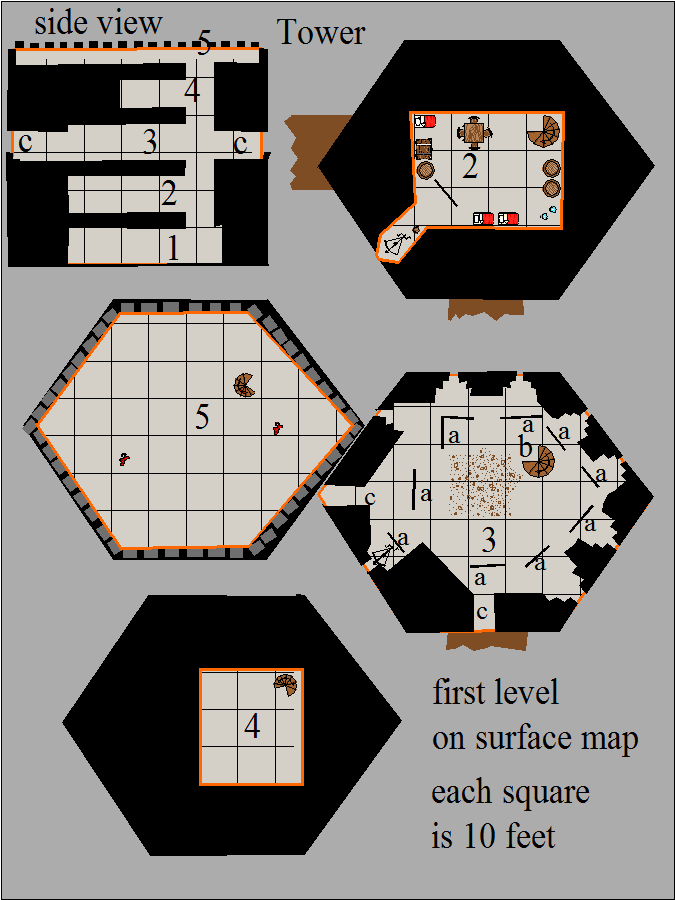
The surface map of this castle plan is made up of four 180’ x 240’ map sections. Thats four sheets of graph paper. The tower map was drawn on one sheet of graph paper.
Author
Bill George
Categories
South Hemisphere
Posted
Author
Bill George
Categories
South Hemisphere